Thursday, April 25, 2019

The Camino Real (The "Silver Route")

Mexico’s Camino Real, the “Silver Route” 

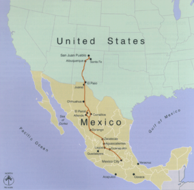
Mexico’s has an historic route called the Camino Real or, more formally, the  “Camino Real de Tierra Adrentro” (“Royal Road of Interior Land”), a commercial route that extended from the Valley of Mexico to Sante Fe, New Mexico (16th – 19thcenturies).  The route, then a trail traveled by foot, horses and wagons, included many outposts –forts, haciendas and chapels- to protect the Spanish travelers from attacks by indigenous peoples, especially the Chichimecas.  The route was also called La Ruta de la Plata (“The Silver Route”), because it followed a chain of volcanically formed mountains where minerals such as silver, gold, copper, turquoise and salt were mined.  The 2,560-kilometer (1600-mile) route, now an UNESCO World Heritage Site (Patrimonial Mundial), has 59 historic points along the way.  

CaminoRealAdentro.png

This route was well established by indigenous kingdom and tribes long before the Spanish arrived in the 16thcentury.  Elcamino, used for hunting and trade, connected important locations in Meso-America and the Rocky Mountains by the year 1000. The route follows the long, rugged Sierra Padre Mountain chain, emblematic of the breathtaking “Western” landscape.  

El Centro Historico, San Miguel de Allende
Many of the pueblos in this blog or in my book projects are either directly on el Camino  (Guanajuato City, San Miguel de Allende, Sombrerete) - or were functioning offshoots, such as Dolores Hidalgo, Mineral de Pozos, Calvillo, Real de Asientos, Pinos and Nochistlán.  The adjacent off-shoot towns provided essential services for mining and traveling on the Camino Real, such as security out-posts, banking, supplies and food sources like ranching and farming (San Miguel de Allende, Dolores Hidalgo).

Sombrerete, a Pueblo Mágico on El Camino Real
 
Many of these pueblos have historic Camino Real sites and structures such as churches, bridges, cemeteries, mines, aqueducts, etc.. El Camino now consists mostly of highways and roads that connect or link the recognized sites and structures.  Many of these sites are fascinating and scenic subject matter for painting or photography.  I urge you to visit them. 

The Historic Church/Convento, Atotonilco (San Miguel de Allende)

 My current residence in San Miguel de Allende is on the official route; and several painting locations in my book are Patrimonial Mundial sites. I intend to emphasize, whenever feasible, these captivating sites in future writings. 

Pinos, Pueblo Mágico-an Old God & Silver
Town. 
The follow link summarizes the Camino Real clearly and succinctly: 
https://en.wikipedia.org/wiki/Camino_Real_de_Tierra_Adentro
Monday, April 15, 2019

The Sierra Gorda Mountains: A Scenic Route

The Sierra Gorda Mountains of Mexico 

The pinnacle of Bernal. This is the second highest monolith in North America.
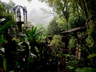
 I recently returned from a research trip to many towns in the Sierra Gorda Mountains in the State of Querétaro in central Mexico in a region a few hours north of Mexico City.  The trip was rewarding because I “discovered” a number of pueblos and communities that deserve coverage in another book. The places are (from west to east): Bernal de Peña, Piñal de Amoles; and Jalpan de Serra, a town with a group of five Spanish Franciscan Missionary churches (misiones) that are, collectively, a United Nations World Heritage Site(s). From Jalpan, I took a quick trip to Xilitla where Sir Edward James’s incredible garden is the main attraction. Bernal, Jalpan and Xilitla are official Pueblos Mágicos. Together, these places provide a plethora of scenic beauty and historic charm for visual artists and architects, a region where one could spend a lifetime documenting the beauty. I will write about each individual town in more detail in future postings. 

A view of Pinal de Amoles
The Sierra Gorda Mountains are a sub-region of the famous Sierra Madres Oriental, a mountain chain that runs north-south through eastern Mexico. They were formed by a combination of tectonic plate buckling, along with volcanic forces.  As such, the mountains are rugged, varied and panoramic. The area I explored was on the eastern slope of the Gorda where increased rainfall produces lush, sub-tropical topography. All of the above towns and places are located in these breathtakingly picturesque mountains. 

La Parroquia, the church that is the focal point of Pinal.

My research trip took several weeks.  I traveled by public transportation the whole way.  This includes a luxury bus (Primera Plus bus line) from the City of Querétaro to Jalpan; then regional bases and vans (that stop frequently), and a small car driven by my licensed tour guide to visit the mission churches scattered among Jalpan’s surrounding mountains.  Travel time from my origin, San Miguel de Allende, to Jalpan de Serra takes around 6.5 hours (that includes changing buses in the City of Querétaro). 

The Mission Church, Jalpan de Serra.
The road to Jalpan and Xitlia twists through the dense mountains, including heart-pounding hairpin curves edged with cliffs that plummet into canyons below.  (Because of the scenic, pulse-racing drama, this route is popular for motorcycle touring). By mistake, I got of the bus in Pinal de Amoles-early and unplanned-due to confusion on my part.  This was a delightful surprise because, standing at the bus station off the narrow road, I saw spectacular views and decided to stay for a couple of nights on my way back. This rewards my philosophy of finding such places that are “off-the-beaten-path”.

This author map-making at a Mission church.

This posting is just a teaser to explore this scenic route.  I plan to write about each town and place in more detail in future postings.  Adios!       4-15-2019

A view in Sir Jame's garden, Xilitla.


Monday, April 1, 2019

Dolores Hidalgo, Pueblo Mágico

Dolores Hidalgo, Pueblo Mágico

The road from Guanajuato to Dolores Hidalgo climbed steadily, looping around old, sun-bleached buildings, craggy outcrops and groves of weather beaten oaks. The bus that stopped frequently to pick someone up, or drop someone off. Country music blared from the speakers (when the reception was good), but often faded into silence.  Vistas opened and closed like the parting of curtains as we wound through the mountain passes …”  [journal entry Jan 15, 2016]
 
La Parroquia Church. Jardín Principal
If you ever wondered what an authentic modern-day ranching town is like (or not like), Dolores Hidalgo may fit the bill.  A town located in a broad, flat valley in central Guanajuato State, Dolores Hidalgo is considered the “heart of Mexico”, as this is where the insurrection against Spanish colonial rule began (1810-11) –an insurrection which led to the revolution and the founding of the country when the courageous priest, Miguel Hidalgo, led a miners’ revolt against the Spanish colonial rulers. Essentially, Dolores Hidalgo is the equivalent of the towns of Concord or Lexington -where the American Revolution began.

A Streetscape, watercolor.

Although a popular destination for Mexicans interested in their National history, Dolores Hidalgo does not have a “touristy”, international character. Rather, it’s an authentic Mexican town located in a region known for agriculture, ranching, forestry and mineral extraction.  Dolores Hidalgo has a strong commercial pulse, a place that supports a vibrant market area (mercado), and shops (tiendas, botegas) of every stripe.  The town also has a small university that supports a youthful culture with institutions (museums, craft shops, etc.), businesses, services and cultural events. Located in ranching country, Dolores has an authentic “cowboy” culture, noticeable as you pass about town, with many of the men wearing sombreros and cowboy boots. Pickup trucks outnumber autos. For those interested, there’s also a rodeo held on Saturdays. The above map/illustrative plan shows some stunning places to paint in Dolores Jardín Principal.  The map is entirely made by hand and is colored by watercolors.  

Courtyard at Temple Llanido

I selected Dolores Hidalgo because of its significant contrasts to Guanajuato, San Miguel de Allende. Dolores Hidalgo is more “laid-back” and less intensive, a town where the pace of life is slower, more rooted to the earth.  This is a place for artists who enjoy painting gardens, enchanting courtyards, architectural details -and figure studies from café tables and park benches. 
 
Illustrative Plan, Jardín Principal, watercolor & graphite on Arches paper

Dolores Hidalgo is laid out with a grid plan, the streets forming small, nearly square blocks.  The streets are narrow and edged with pueblo-style, one-story casas; the traffic is mostly one-way.  To compensate space-wise for the narrow streets, most casas have interior courtyards to allow the sun and breezes to enter.  As such, you’ll find many delightful restaurants, cafes and shops included in, or clustered around, interior courtyards.  Many are like cloistered gardens, with orange trees, wisteria, potted plants and often a fountain gurgling in the center. 

The Bridge Over El Rio, oil on canvas

Let’s now explore Dolores for its prime painting locations, beginning with its central park, el Jardin Principal. (My book covers about a half-dozen picturesque locations in Dolores Hidalgo.  These places are lavishly presented with maps, drawings and paintings).

Plaza Compositores - Where Musicians Play day-long.

Map/Illustrative Plan of Plaza Compositores
To purchase a “Painting Mexico” book from publisher (less expensive): 

http://www.blurb.com/b/8596527-painting-mexico-magical-pueblos-in-guanajuato

(This site is set to allow you to view all the pages in the book).

To purchase “Painting Mexico” book from Amazon: http://a.co/65YVml8   

Please help me fund my art-travel books by purchasing prints on FineArtAmerica.com.  (All expenses for the production and publishing of these books are self-funded by me.  I consider much of my effort to promote scenic tourism to towns in Mexico to be charity).

To purchase prints of some of the paintings, drawings & maps in this book: www.fineartamerica.com“Jack Hannula” 

Please help!  Purchasing a print of this map will help me to (self) fund the costly production and publishing expenses of my “Painting Mexico” books. In other words, please help me help Mexico’s “magical towns”.  Many are poor.   

I am frequently asked, “How do I buy your art, Jack?”  Because of these many requests, I am making quality prints of my maps and some of my art available for purchase on the Internet.  To purchase prints, follow this link: www.fineartamerica.com“Jack Hannula”.  

San Miguel´s “Globo” Skyscape J. K. Hannula San Miguel is routinely acclaimed as the world’s most beautiful -or “most livable” town/small...